Assessment Documents Available to Download:
Conservation practitioners and agencies across the state recognize the importance of riparian restoration, but their time and resources are spread thin. In order to make the most effective decisions possible, stakeholders need the information required to weigh costs against benefits of this restoration.
While working in the Mokelumne Watershed to develop tools to quantify the benefits of riparian habitat, stakeholders helped identify a need to inform and improve outreach and funding decisions for conservation. To fill this information gap, we set out to:
- Quantify the remaining riparian area in need of restoration along the Mokelumne River;
- Estimate the costs and benefits (using the riparian habitat quantification tools) of conducting the needed restoration;
- Identify the types of restoration that provide the most benefit per cost and identify areas for focused landowner outreach.
The assessment results can be found in the resources box at the top right. Key results are included in the Executive Summary, while the full cost and benefit information is included in a more comprehensive spreadsheet titled “Results.” A companion User Manual is included to help practitioners understand and use these resources. For those who would like to dive more deeply into the geographic information that informed this assessment, GIS map files are also available for download.
We encourage all stakeholders and agencies actively conducting restoration in the Lower Mokelumne Watershed to download and use these resources to support their decision-making. Conservation practitioners outside of the Mokelumne watershed can also use this information to build on our approach and methods for their own analyses elsewhere.
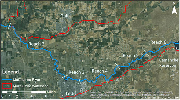
Map of study area assessed in our analysis, which runs along the Lower Mokelumne River from the confluence of the Cosumnes River upstream to the Camanche Dam: Reaches 2-6, as described by Reeves & Jones (2004).
While we understand that many considerations go into funding decisions for restoration, this information can be incorporated into Lower Mokelumne River conservation strategies. The result – achieving conservation outcomes like clean water and wildlife habitat in a more cost-effective way – is a win-win for the environment, landowners, and restoration funders.
Learn more about restoration organizations working locally along the Mokelumne River:
CITATION
Sustainable Conservation. (2015). Lower Mokelumne River Restoration Assessment. Retrieved from https://suscon.org/ecosystemservices/Mokelumne_River_Assessment.php
DISCLAIMER
The Assessment has been developed with intentional transparency and easy extension to be adapted to other watersheds. As such, permission to use, copy, modify and distribute this publication and its referenced documents for any purpose and without fee is hereby granted, provided that the following acknowledgement notice appears in all copies or modified versions: “This content was created in part through the adaptation of procedures and publications developed by Sustainable Conservation, but is not the responsibility or property of this entity.”
Learn more about the Mokelumne River Watershed history and past restoration efforts at The Nature Conservancy’s Salmon Snapshot: Mokelumne River.